Because Talk Like a Pirate Day is coming up, or maybe I have an unnatural curiosity about pirates in general – I thought it would be cool to travel like a pirate, but most pirates, of course, didn’t register their route with the harbour authorities, so we don’t really know how and when they did the things they did. Any honestly we can’t even trust the historical accounts of those men and women who choose this life at sea.
But there are a few, whose names still live in infamy, they may not have had the wit and charm of Captain Jack Sparrow – but they can sure capture our imaginations. One such seafarer is James Cook, who covered much of the planet during a career of remarkable success – paying equal attention to north, south, east and west in three voyages which redrew the global map.
His presence lingers in many of these places – whether you visit by sea or by land…
Who was Captain Cook?
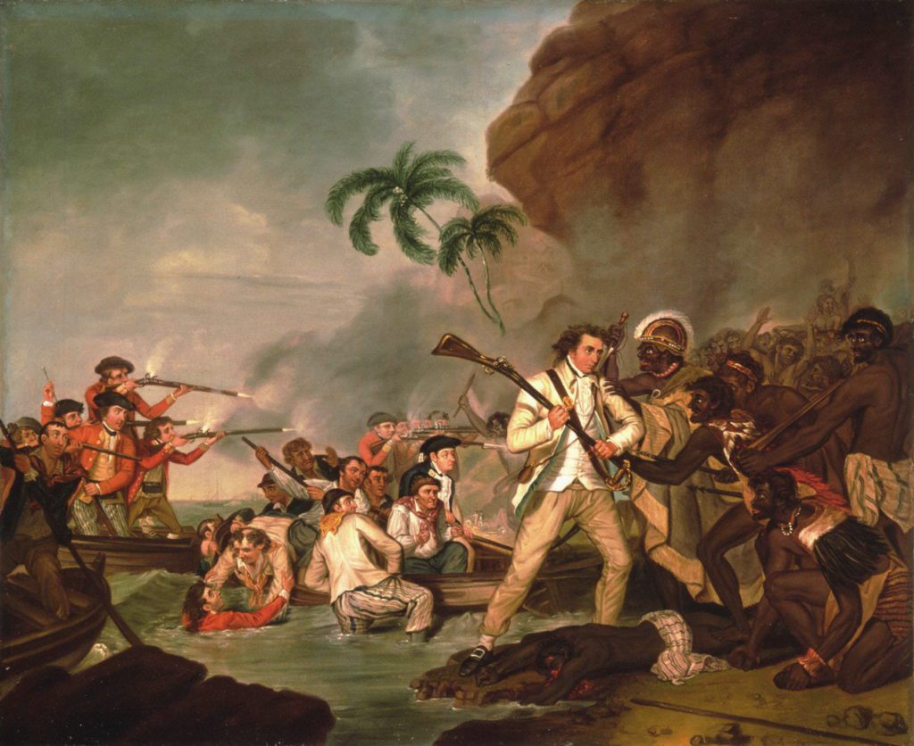
Captain James Cook was an eighteenth-century British explorer and navigator who made numerous celebrated voyages across the Pacific Ocean before he was killed by islanders in Hawaii in 1779.
Born in Yorkshire in 1728, Cook grew up on a farm before his mathematical and navigation skills helped him climb the ranks of the Royal Navy and eventually to lead three celebrated Pacific voyages.
Regarded as a humane explorer, he set numerous records, including becoming the first European to land on Australia’s east coast in 1770 during a secret expedition to confirm the existence of a southern continent. He also led the first voyage to circumnavigate New Zealand and was the first European on record to discover Hawaii.
It was this last voyage that led to his death after tensions broke out between his crew and the locals.
Early career (1757-1767) Quebec
Before his voyages, Cook honed his skills in the Royal Navy. He took part in the siege of Quebec City in 1759 – a midpoint to the Seven Years’ War (1756-1763) between Britain and France on what would become Canadian soil. His abilities as a cartographer were noted and he was sent to chart the mouth of the St Lawrence River.

Newfoundland
His work on the St Lawrence was rewarded in 1763 with a first command – of the schooner HMS Grenville. Cook spent the next five summers on the perimeters of Newfoundland – surveying its southern coast between the Burin Peninsula and Cape Ray. This boosted his profile and led him to write that he now intended to go not only “farther than any man has been before me, but as far as I think it possible for man to go.”
If Cook’s initial foray would lead to Australian shores, it would first have to survive a rounding of the infamous tip of South America – an enemy that, 64 years later in 1832, Charles Darwin described as “this notorious promontory… veiled in mist… surrounded by a storm of wind and water”. Cook passed it on HMS Endeavour’s progress from Plymouth to the Pacific. He would return to the Tierra del Fuego archipelago on the homeward leg of his second voyage.
Tahiti
Cook had nominally been dispatched to the Pacific by the Royal Society to observe the transit of Venus in 1769 – but also, clandestinely, by the government of George III to seek the rumoured “Southern Continent” for colonial purposes. The cover for the voyage was provided by Tahiti, where the Endeavour docked on April 13, 1769, anchoring on the north coast at Matavai Bay to take astronomical readings. The ship would continue southwest, to Bora Bora and Raiatea – once Cook had read sealed orders revealing the plan.
New Zealand was not new to European eyes when Cook saw it on October 6, 1769 – the Dutch seafarer Abel Tasman had discovered it in 1642. But the British navigator mapped it with such accuracy that the gap between the North and South Islands is still known as the “Cook Strait”. He remained cynical that a vast land lay beyond, writing that his findings “must be allowed to… set aside… the arguments that there must be a Southern Continent.”
The body of water splitting New Zealand’s North and South islands is still known as the Cook Strait Credit: istock Australia
Although Abel Tasman had spotted a section of Australia in 1642 – Tasmania, which he had christened “Van Diemen’s Land” – he also missed the bigger picture. Thus the Endeavour was the first European ship to come within visual range of the main Australian landmass on April 20, 1770. Cook would pilot her north-east for a world-redefining landing at Botany Bay (now the Sydney suburbs) on April 29.
Second voyage (1772-1775) Tonga
A year after his return to Britain, Cook headed back to the southern hemisphere, this time on HMS Resolution. An odyssey that took in southern Africa and the Cape of Good Hope – and sailed across the Antarctic Circle – would see a return to New Zealand, passage through the Cook Strait, and another date with Tahiti, en route to Tonga.
Modern echo: Tonga is an emblem of Cook’s voyages. Its charm infuses the seven-night yacht break in the islands sold by Sunsail (0330 332 1201; sunsail.co.uk). From a basic £1,750; flights not included.
The Resolution became the first ship to make a recorded docking at South Georgia Credit: Getty South Georgia
The latter half of the second voyage endured cold conditions. The Antarctic Circle was crisscrossed in early 1774 before Cook inched east to Cape Horn (see above) and another relatively blank page – the South Atlantic. Here, the Resolution became the first ship to make a recorded docking at South Georgia – in Possession Bay, on the north coast – before the “adjacent” South Sandwich Islands came into view on Jan 31. “I was now tired of these southern latitudes, where nothing was to be found but ice and thick fogs,” Cook would muse wearily in his journal.
Third voyage (1776-1779) Tasmania
The aim of the explorer’s last hurrah was to locate the Northwest Passage between Asia and North America. But first, the Resolution went south-east from Plymouth to familiar waters. The second voyage had flirted with Tasmania. Tobias Furneaux, Cook’s assistant, piloting HMS Adventure, had charted the south and east coasts of “Van Diemen’s Land” in 1773 – during three months when the ships had been separated by fog. Cook landed on the south shore on Jan 26 1777, but, like Tasman and Furneaux before him, missed the Bass Strait – and the fact Tasmania was not part of the main Australian landmass.
Tasmania’s Wineglass Bay is perfect for a peaceful break Credit: Getty Oregon
After “discovering” Hawaii (see below), Cook went up through the Pacific, seeking the little-known North America that lay above the Spanish colonies of California. On March 6 1778 he sighted Cape Foulweather, on the lip of what is now Oregon. “The land appeared to be of moderate height,” he would write, “diversified with hill and valley and almost everywhere covered in wood. There was nothing remarkable about it.”
The Aleutian Islands
Vancouver Island was not Cook’s sole dalliance with the upper Pacific. The Bering Strait and the Northwest Passage would prove icily impassable – but, turning south again, HMS Resolution would encounter the Aleutian Islands. Cook dropped anchor at Unalaska – a sizeable chunk of an archipelago which is now tied to the USA and Alaska – staying for three weeks of repairs during which he spoke with islanders and Russian traders.
Hawaii
Cook’s story reached an imperfect end in the mid-Pacific. He became the first European to visit Kauai – landing at Waimea, on its southwest shore, on Jan 18, 1778. He was warmly welcomed – enough so that, having been defeated by the Bering Strait, he chose to retreat to the archipelago in 1779, steering Resolution into Kealakekua Bay on the west flank of Hawaii (the “Big Island”). This time, the locals would become less cordial. After an argument about a missing tender, and a reckless attempt to take the Hawaiian king Kalani’opu’u hostage, Cook was stabbed to death in the surf on Feb 14. He was 50.

“History is written by the victors” – Winston Churchill


